Thursday, July 3, 2014

Pentagon Barracks, Baton Rouge LA


The Pentagon Barracks is one of several unique places that I happened to stumble upon while on my Spring Road Trip.  I had seen a reference to them while looking through tourist information in the hotel lobby, and spotted them as I pulled up to the Louisiana State Capitol. When I ventured briefly out onto the Capitol's observation deck I was puzzled about why they are referred to as "pentagon" when there are only 4 buildings and, therefore, only four sides rather than five.  Time for a little research! But little did I know the problems I would have as the available information is sketchy and sometimes conflicting.  Plus, I felt that some of the explanations I found were not really well documented.  What I share here is what I sifted through and found to be accurate.
  • This area had been settled by the French after French explorer, Pierre Lemoyne, Sieur d'Iberville, discovered this area along the Mississippi River in the early 1700's.   
  • In 1763 the area was ceded to the British.  They built the first fort in 1779 and named it Fort Richmond. In September of that year Spain would capture the fort and re-name it Fort San Carlos. 
  • In September 1810 it was captured by a group of revolting citizens who then formed the short-lived West Florida Republic and changed the name to Fort Baton Rouge.
  • In December of that year the republic requested acceptance into the union and U.S. soldiers assumed control.


  • 1816-because of its location on the river the fort was selected as an ordnance depot by the U.S. Army Ordnance Department. A major expansion of the fort was undertaken during the years from 1819 to 1823.  Plans for the depot were drawn by a young Army engineer, Lt. James Gadsen, and the construction contract awarded to Joel Hill.  Hill was already under contract to the Quartermaster department to build four barracks buildings and a combination commissary-warehouse building.
  • 1825-the five building complex was completed and it was at this time that the quartermaster building complex became known as the Pentagon Barracks.  The commissary-warehouse building was soon torn down due to faulty construction, leaving only the four barracks buildings.  The fort became known as the Baton Rouge Arsenal and Ordnance Depot and soon was the largest in the South; during the Mexican War it was the military’s main supply depot. 
  • 1861-state militia forces led by Louisiana Governor Thomas Overton Moore captured the fort. The Confederate Army would assume command soon afterward; the ordnance in the fort supplied many Louisiana volunteer units.
  • 1862-in August the fort was captured by Union forces, renamed as Fort Williams, and held by them for the remainder of the war, continuing to function as an ordnance depot.
  • 1869-the fort was formally transferred to the Quartermaster Department.
  • 1879-the post is deactivated June 6th and the Army leaves.  Only one sergeant remains as a caretaker.
  • 1884-the property was transferred to the Department of the Interior. The General Assembly of Louisiana passed a resolution granting full use of the property to Louisiana State University.


LSU began using the facilities of the former fort for classes in 1886 and would be given full title to the property in 1902.  The university would move to its present day location in 1926, but the barracks continued to house cadets until 1932 and then co-eds until 1950. The other old buildings on the post would be torn down in 1931-1932 to make room for the new State Capitol. 

In 1951 ownership of the barracks was transferred to the State and the barracks were renovated into apartments and office space.  A complete interior renovation was undertaken in 1966 and again in 2006 so nothing remains of the interiors of the barracks used by the military or LSU.  Today these apartments are rented out very cheaply to legislators (yes, there is quite a controversy in LA over that!).


The barracks originally had 4 fireplaces; the galleries on both side of each building were added around 1834.  The Historical American Buildings Survey conducted in 1978 describes the galleries as being the finest example of Greek Revival colonnades in the area, but then later describes them as being Tuscan in style, and makes the observation, "Despite the fact that the columns are too widely spaced and entasis is improper, the colonnades are large and boldly formed, creating an overall effect of strength". There are many sources of old photographs of the barracks available on the internet, but click here to see a few that show good views of the buildings and the area around them.

 Today the barracks are not officially open to the public, but I didn't know that when I was there.  It was early on a Sunday morning and I strolled around the grounds enjoying the serenity of the park area in the middle of the complex and wishing that I could be there to see this very large magnolia when it was in full bloom!

Sunday, May 18, 2014

San Pedro Springs

(After posting this I did more research (imagine) and have added a few updates in italic to some of the facts.)

There is no doorway for us to walk through in this post, but the San Pedro Springs and surrounding area has more history than can be recounted in just a few words. In researching the Park I have collected enough data to write a book. I have found myself reading through archeological abstracts and other surveys, spellbound by the findings.  Needless to say, I have struggled with writing this post because there is so much to share, so I'm going to offer just a few facts and pictures for now.

This area just northwest of downtown San Antonio has been a gathering place for humans for thousands of years.  Prehistoric artifacts including bones, projectile points, and stone tools have been found during archeological investigations. 

In times of plentiful rain the Springs will flow from the openings in these rocks as well as from other springs scattered throughout the Park
In 1709 a group of Franciscan priests led by Fathers Antonio de San Buenaventura de Olivares and Isidro Felix de Espinosa came through this area on an expedition to the missions of East Texas.  They found a band of native Coahuiltecan Indians who called themselves the Payayas living here in their village, Yanaguana.  Father Espinosa named the springs agua de San Pedro. Father Olivares felt this would make an excellent place for a mission settlement and would return in 1718 to establish the mission San Antonio de Valero.  Its location is believed to have been somewhere in close proximity to the San Pedro Springs (this mission would move several times and its final location would become famous as the site of the Battle of the Alamo).

Early explorers would often confuse these springs with the nearby springs that create the headwaters of the San Antonio River.  The abundant supply of water from both springs was diverted to mission farmlands through a system of acequias built by Old World craftsmen who were skilled in designing and building perfectly functioning waterways that used a gravitational flow system. 

 
This acequia is what remains of the Alazan Ditch, an ill-fated concrete project engineered by Anglo businessmen in City Hall in 1874. It never functioned correctly and it was later reported that the City Engineer had "discovered that water will not run uphill" (San Antonio Express, April 16, 1875).

King Phillip V of Spain declared the area around San Pedro Springs an ejido  (public land) in 1729. When the Canary Islanders arrived in 1731 they were given temporary use of the land for farming.  It would be used by the military for encampments as well as civilians for public gatherings.  A plaque in the park declares that this is the second oldest public land in the United States; however, I read in several places that it is actually one of the top 10 oldest.  Records of the original boundaries were lost during the turbulent years of the early 1800's.  In 1851 the City re-established the boundaries based on the memories of older residents. 

The bandstand was built around 1890 over a pit that had housed bears.  Hot air balloon rides were offered and daredevil parachutists offered entertainment.  Shooting matches and horse races also took place in the Park.

In 1864 the Park as we know it began to be organized.  Jacob J. Duerler received a 20-year lease on the property from the City in return for his management.  He built fences, added landscaping, and cleaned out the Springs.  Fish ponds, rental boats, and a building with a ballroom and bar enhanced the property. It became so popular that a mule-drawn cart began making continuous runs between the park and downtown.
 
 
The pool is the centerpiece of the park today.  Originally there was a small lake created by the flow of the springs.  Following numerous renovations the City opened the first municipal swimming pool in 1922 using the old lake bed as a base.  The lake was naturalistic and still replenished by the springs.  Progress wasn't kind. The drilling of artesian wells eventually dried up the springs and in 1940 the pool was closed.  In 1954 a new, modern cement pool was built, complete with chain link fencing; a new tennis facility was also constructed. That pool was eventually closed and sat empty until the City undertook an extensive restoration project for the park that included this pool that closely resembles the 1922 version. It is used as a City pool during the summer months, and is considered a lake during the remainder of the year (of course, there are those that swim in it off season!). It is not filled with spring water, but with municipal water.  In the swimming season it is surrounded by a wrought iron fence to prevent entry except through the bath house (on the right in the above picture).

 
This grotto looks much like it did in postcards printed in the early 1900's.  I read several explanations of its original use and suspect that most of them are just folklore.  At some time in the past there was a spring or some source of water that issued from the top and moss and ferns would cover the grotto.  Since our area is in a drought there is no water flowing. (Further research shows that originally there was a summer house built over the spring that flowed in this location.  That building was torn down and this grotto was built over it.  The spring would flow through a pipe and down the sides of the grotto where ferns were planted.)

 
This building is referred to as the Block House, but has many other nicknames.  Its origin is unknown, but it is thought that a portion of it could pre-date the arrival of the Canary Islanders in 1731. One urban legend is that this was Santa Anna's home (it was not). The small slits were obviously for rifles.(Archeological surveys determined that this structure was built around 1850, but its original use is still unknown)


Old photos show that this star shaped structure was originally topped with ....a cow's head that appeared to be made of stone.


A close up of one of the main springs.  The last time the springs were active was in 1992. IF we ever have a substantial rain again you can be sure that I will be here to check on these springs!
There are 3 springs contained in this rock walled enclosure 
 
 
View of the main springs area from cliff above them


There are many very large trees in the Park.  These cypress trees along the side of the pool are quite large, but there are several oaks that have a tremendous base and wide, spreading branches.  Obviously, they have all witnessed many years of the history of this enchanting ejido.

San Pedro Springs Park was entered in the National Register of Historic Places in 1979.

Thursday, May 1, 2014

Oak Alley, part 2

(This is a continuation of the previous post, Oak Alley, part 1  . In it I forgot to mention that an owner prior to the Stewarts, Jefferson Davis Hardin, had purchased the plantation in 1917 and had made an unsuccessful effort at restoration.  He is credited with saving the Big House through his replacement of the heavily deteriorated roof.)

I spent about two and a half hours at Oak Alley and never felt overwhelmed like I sometimes do in places with many things to see.  I did not try to see everything there (save something for the next trip, right?), but still felt very relaxed as I walked around the grounds using the excellent Visitor Guide & Map they supplied. 


The building that the Stewart's used as a garage now has two vehicles on display that are representative of the Stewart era.  On the right is a 1928 Ford Model "A" Phaeton sedan and on the right is a 1929 Ford Model "A" truck.
 

One of the exhibits I did not explore was the slave quarters.  Just glancing in as I walked by I could see many exhibits.  I don't remember where I picked this up, but normally the slave quarters were not located as close to the house as these are.  So I'm not sure if this was an unusual occurrence or if these buildings were moved from somewhere else.  (Just to note, I'm sure that actual slave quarters were not this neatly built and well roofed!)

These sugar kettles were scattered over the grounds.  They were part of the tedious process of extracting sugar and molasses that was done on every sugar cane plantation.  The kettles were graduated in four sizes ranging from 7.5 feet (the grande) to 4 feet (the batterie) in diameter.

The object visible at the top right of this photo of the dining room is the bottom of the punka.  This fan would swing back and forth above the table while the family enjoyed a meal; it would be "powered" from a corner of the room by a small slave boy pulling a rope to move the fan back and forth.  These are actually of Indian origin and I'm not sure how they were brought to the southern states (future research project) but they served their purpose.  I had to think that the little boy pulling the rope would have to be fairly strong to keep pulling the fan back and forth throughout a meal.

The bedrooms were beautiful, filled with many period pieces like this cradle and day bed next to it.  However, I just could not get excited about the thought of sleeping on a mattress stuffed with moss!
Excellent!
 
(Restaurant is on the left)
The restaurant is located in a building constructed around the turn of the 20th century and the gift shop is located in what was originally one of the shed's constructed while Mr. Hardin owned the plantation. The restaurant offered a nice menu and I bought a cookbook that had their recipes in it, many of which are Mrs. Stewart's.  The gift shop featured a nice selection of books; however, there wasn't one on the history of Oak Alley.

The love that the Stewart's put into the restoration and maintenance of Oak Alley is very evident everywhere. To ensure that the plantation was preserved for future generations Mrs. Stewart established the non-profit Oak Alley Foundation for the purpose of maintaining and preserving the Big House and 25 surrounding acres.  The property was listed as a National Historic Landmark in 1974.

Wednesday, April 16, 2014

Oak Alley, part 1

 Oak Alley Plantation has been on my list of places to visit for a long time and was one of the definite stops on my recent road trip.  It is now on my list of places to go back to visit again; I want to spend a night in one of their cottages and enjoy several meals in their restaurant!
The Big House


The Big House and its dependencies were built over a three year period between 1836-1839 almost entirely by slave labor using local materials.  The finishing touches such are marble mantles and floors were imported from Europe and no expense was spared.  Wealthy planter Jacques Telesphore Roman received the property in a plantation swap with his brother-in-law.  The house was constructed as a gift for his bride, Celina, who was 16 years younger and accustomed to the city life of New Orleans. Built in the Greek Revival style on a square, central hall plan the design is thought to have been drawn by Celina's architect father. The contractor was George Swainey.
 
After Jacques' untimely death in 1848 due to tuberculosis Celina tried to manage the plantation; however, as with most women of that time she had no training in managing a large sugar cane plantation. By the time their son, Henri, assumed control of the plantation in 1859 the plantation was almost bankrupt.  Despite his efforts the plantation still was not profitable, and Henri slipped heavily into debt.  The plantation was sold at auction in 1866 to John Armstrong for $32, 800, solely for its value as a sugarcane plantation and not for the house or dependencies.
These oaks pre-date the house by over a hundred years.  They were planted in the early 1700's by an unknown settler.  I have to wonder if he had actually built a house here or just planned on building.  The 28 oaks are spaced 80 feet apart and reach almost a quarter of a mile to the Mississippi River.  When the house was built the river was visible from the front veranda as the levee was significantly lower then.  When the early Capuchin Fathers arrived in 1722 to establish St. James Parish, the trees were described as being of mature size. 
 
Today at 300 years of age they are considered to be middle aged and are members of the Live Oak Society where each tree is registered and has its own name.  Miraculously the trees and the plantation escaped the fury of Hurricane Katrina, sustaining only minor damage.
 
Madame Roman had named her house Bon Sejour which means "Good Stay" (A Good Place to Stay), but as the tour guide explained it was always knows as Oak Alley because the river boat captains would tell travelers that when they saw the alley of oaks then they were half-way between Baton Rouge and New Orleans!
After a succession of owners the house had fallen into disrepair.  Fortunately, Mr. Andrew Stewart purchased the property in 1925 as a gift for his wife, Josephine.  She hired Richard Koch to perform an extensive restoration on the house that included portioning the rear rooms of the first floor and removing one of the roof dormers on the front and back of the house.  Mrs. Stewart choose the pale pink color for the exterior of the house as well as the blue green for the shutters and railings.  As is the custom of Southern houses, the ceiling of the veranda is painted a pale blue to abide by the tradition that the blue color will keep birds from building nests.
Mrs. Smith loved the out of doors, preferring to be outside gardening or riding her horse.  She was fond of the English style of gardens, particularly favoring boxwoods.  These are over 100 years old.  The building at the back of the picture is thought to have been the site of the original kitchen.  The Stewart's used this building as a garage for their cars.
 
to be continued...


Thursday, March 20, 2014

Baton Rouge Water Company Standpipe

What is that, I thought.  I walked over to this unusual structure and walked all around it trying to identify what it is or was.  There were two plaques, both stated that it was on the National Register of Historic Places.  But nothing else to identify this mystery tower facing Lafayette Street in Baton Rouge.

A little online research identified this as the Baton Rouge Water Company Standpipe.  It was constructed in 1888 after the Common Council of Baton Rouge contracted with E. Smedley and John H. Wood of Dubuque, Iowa to build a water works company.  They were also charged to maintain and operate the company. The original standpipe was built on a leased piece of ground adjoining the water works company.  It was 100 feet in height and 15 feet in diameter and constructed of riveted wrought iron plates that ranged in thickness from 5/8 of an inch at the bottom of the structure to 1/4 of an inch thick at the top. The foundation is 10 feet deep and there are fabricated triangular brackets at the base. An access ladder climbs up one side. Original capacity was 132,500 gallons although the contract only mandated a standpipe with 100,000 gallon capacity that could furnish 2 million gallons of water in a 24 hour period.


In 1937 plates were added to increase the capacity of the standpipe; this accounts for the present day height of 110 feet.  In 1938 a metal umbrella roof replaced the original wooden cover. Originally it held treated water from the Mississippi River and then later water from the wells that would be drilled in 1889 and 1896. This standpipe was the only elevated water source in Baton Rouge until 1938. The standpipe has not been used since 1963.  Today a fountain (under renovation or repair, thus the yellow tape) surrounds the structure and there is no sign of the Water Company building.

.

Tuesday, February 18, 2014

Magnolia/Mobil Service Station

This building can easily be identified as a former service station by the familiar, bright red Pegasus perched on top!  It no longer welcomes clients to drive up for a fill up and a check under the hood, but it is a functioning business in a building that has been preserved and protected.
The station was built in 1934 by Dallas based Magnolia Petroleum Company.  The local architectural firm of Adams and Adams designed the station in the then popular Spanish Colonial Revival style. An article in the San Antonio Light newspaper in 1937 described it as "one of the most beautiful and picturesque service stations in the Southwest."

In 1985 Mobil Oil sold the building. The San Antonio Conservation Society negotiated with Mobil Oil and the new owner to protect the Pegasus sign.  The resulting agreement allowed for the first time for the company's trademark to be on permanent loan to a private entity:  the Society's Foundation. A separate agreement between the owner and the Society requires the owner to maintain and preserve the Pegasus sign.

An early picture shows what appears to be pumps located along this side of the building.  The picture is small and details are hard to distinguish, but it appears that the protrusions from the top, left side were posts that formed a type of pergola canopy.  From the picture I can't tell if there were service bays, but I can't imagine a service station from this era not having at least one service bay.

An article in the September 1, 2012 San Antonio Express News stated that there was a parlor where ladies could sit while having their car serviced.  The original tile from the parlor can still be seen in the store today. (Note to self, time to go shopping and check! Sloan Hall is a delightful gift shop)

The Magnolia Petroleum Company had been established in 1911 and all shares of stock acquired by Standard Oil Company of New York in 1925.  When Socony merged with Vacuum Oil Company to form Socony-Vacuum Oil Company, Magnolia became an affiliate of the new company.  In 1959 Magnolia merged with Socony Mobil and its operations became  part of Mobil Oil Company.
I have always associated the Pegasus trademark with Magnolia Petroleum Company; however, one source I checked indicated that it was a trademark of Vacuum Oil prior to the merger, so I'll have to do some more research. The 30 x 50 foot twin Pegasus's that revolved for many years atop the Magnolia Petroleum Building in Dallas were re-built and reinstalled and re-lit on New Years Eve 1999.  They no longer revolve due to the considerable age of the mechanism, but the Pegasus is considered a beloved, permanent fixture of the Dallas night skyline.

I'm just thankful that we didn't loose this treasure and that steps have been taken to protect and preserve it for the future.

Sunday, February 2, 2014

San Antonio Post Office and Federal Courthouse

Construction of the United States Post Office and Court House in San Antonio began in 1935 and was funded through the Public Works Administration of the New Deal. It was finished in 1936 and opened in 1937. Local architect Ralph Haywood Cameron designed the building in association with renowned Philadelphia architect Paul Philippe Cret under the direction of the Office of the Supervising Architect of the U.S. Treasury Department.

When it opened the basement and first floor were air-conditioned, making it the first post office in the nation to have air-conditioning. Today this building is known as the Hipolito F. Garcia Federal Building and serves as the courthouse for The United States District Court for the Southern District of Texas, but a small post office branch still operates in the lobby. It was added to the National Register of Historic Places in 2000.
 "Its construction accomplished several goals--generating employment, housing all federal agencies in a single building, and streamlining San Antonio's quickly expanding postal needs.
A skillful example of Beaux-Arts classicism, the U.S. Post Office and Courthouse is indicative of the federal government's goal of expressing democratic ideals through classically derived architecture featuring grand scale, symmetry, and refined details.  The six-story building encompasses an entire city block and is constructed of steel and concrete clad in rich local materials--Texas Pink granite and Texas Cream limestone.  The building is polygonal in plan, centered on a central light court.  Its façade (south elevation) emphasizes a centrally recessed porch behind a screen of six monumental Ionic columns, rising to support an entablature that continues all around the building." (Source: U.S. General Services Administration )

East side of building
 
The building is at the north end of the Alamo Plaza Historic District.  The grounds of the Alamo are just across the street and to the right of the main entrance.  The building gives the appearance of confidently watching over the grounds of the Alamo and at the same time gives a sense of guarding all that our Federal government represents.  

"The grand Beaux Arts federal building was a beachhead of centralized, federal power. Through its front south façade, which faces Alamo Square, it linked Texas’s independent frontier spirit with the order and reason represented by the federal government. 
One of the side entrances

 
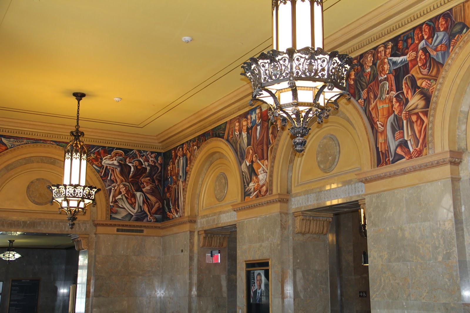
In 1937, New Mexican artist Howard Cook won a national mural competition sponsored by the Treasury Department's Fine Arts Section to paint a 750 square foot fresco in the lobby of the Federal Building. "San Antonio's Importance in Texas History" was completed in May 1939 at a cost of $12,000. The 16 frieze panels depict the history of San Antonio. The mural was painted using the fresco technique of paint applied over wet plaster.  The murals were restored in 1999. These murals and the lobby are stunning; I was totally unprepared for their impact when I first visited the building!
     

The building has undergone a $50,000,000 renovation funded through the American Recovery and Reinvestment Act economic stimulus package.  Trivers Associates of St. Louis provided a sensitive renovation that maintained the historical integrity of the building while adding the required modern updates.  The front entrances are now open again and visitors don't really notice the glass partition that guides them into the security check point to enter the building. Light fixtures like the ones shown with the murals were restored, but re-worked to be energy compliant.  Click on the Trivers link to see beautiful pictures of the inside of the building as well as an aerial picture that shows the open interior space of the building.

This building is remarkable, not only in its design and in its history, but also in the fact that it represents preservation and continuation merged together.